

Mozambique Floods Update
Damage Assessment, Access Conditions and What It Means for Travel
Several days after peak rainfall and cyclone-related flooding in southern Mozambique, conditions have shifted from emergency response to structured recovery. This Mozambique Floods Update provides a clear assessment of damage, aviation status, road access and what current conditions mean for travelers.
International coverage focused on peak-impact flood imagery during landfall. What matters now is geographic precision and operational status. Recovery has moved beyond the dramatic first 48 hours and into measurable normalization.
Where Flooding Was Most Severe
The heaviest rainfall and most visible flooding occurred in low-lying districts within southern provinces, particularly along river basins and flat coastal plains in parts of Gaza and southern Inhambane Province.
Urban flood zones experienced temporary water accumulation where drainage systems were overwhelmed during peak rainfall intensity. Informal settlements and flat urban corridors showed the most dramatic imagery due to surface runoff and water pooling.
Impact severity varied by elevation. Elevated dune systems and reinforced coastal infrastructure zones experienced heavy rainfall and wind stress but did not sustain prolonged standing floodwater in most cases.
Damage is real in defined corridors. It is not uniform across the country.
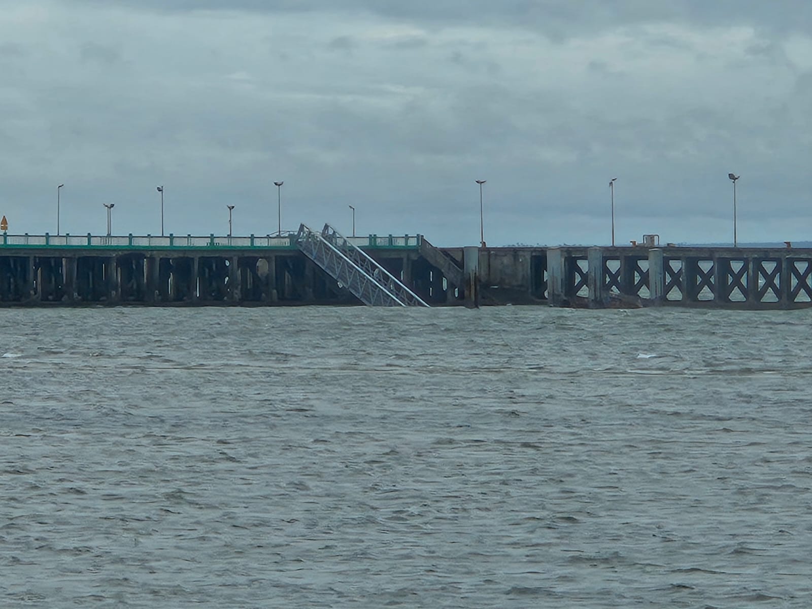
Damage Overview: Infrastructure and Housing
During peak impact:
- Localized wall collapses were reported in vulnerable housing areas
- Roofing stress occurred in wind-exposed districts
- Temporary power outages affected urban neighborhoods
- Standing water disrupted secondary road access
Primary infrastructure corridors, including major highways and aviation facilities, underwent inspection immediately after wind thresholds subsided.
Importantly, there has been no systemic collapse of national transport infrastructure. Recovery has been phased and prioritized.
Timeline of Recovery So Far
First 48 Hours
Emergency services prioritized life safety and rapid assessment. Major highways were inspected for structural integrity. Airports suspended operations during extreme wind thresholds. Power restoration planning began.
Days 3–5
Primary transport corridors were cleared of debris. Standing water began receding in sandy coastal zones. Municipal teams shifted focus from emergency containment to debris removal and infrastructure stabilization. Aviation inspections allowed phased reopening.
Current Phase
Recovery has moved into normalization. Clean-up continues in some urban districts. Power infrastructure restoration is ongoing in isolated areas. Core travel corridors are operational.
Understanding this timeline prevents confusion between peak impact and current conditions.
Airport Operations and Flight Access
Airports in affected southern regions temporarily suspended operations during peak wind conditions for safety compliance.
As wind speeds normalized, runway inspections and navigation system checks were completed. Commercial flight operations have resumed in phases.
Airlines may continue adjusting schedules to manage aircraft repositioning and backlog. However, there is no nationwide aviation shutdown. Regional air access is functioning.
Travelers should confirm individual flight status with carriers, but aviation infrastructure is operational.
Road Conditions and Surface Access
Primary transport routes connecting key coastal towns have been prioritized for debris clearance and inspection.
Major highways are operational with caution in certain low-lying sections undergoing surface repair. Secondary rural roads in flood-prone districts may still require additional maintenance time.
Core tourism corridors are accessible. There has been no long-term regional isolation of established coastal destinations.
Conditions continue improving daily.
Current Conditions in Coastal Tourism Areas
In established coastal tourism regions, floodwater has largely receded following rainfall reduction. Sandy substrates facilitate natural drainage, accelerating stabilization compared to clay-based floodplains.
Resorts and lodges implemented pre-storm protocols prior to landfall. Structural inspections have been conducted in affected zones. Some properties initiated temporary closures for safety assessments and minor repairs.
Widespread prolonged resort shutdown has not occurred across major tourism areas.
Visible clean-up activity in certain urban districts reflects recovery progress, not ongoing crisis conditions.

Marine and Coastal Conditions
Cyclone systems temporarily increase wave height and disturb marine visibility due to sediment movement.
As wind speeds have decreased, ocean swell patterns have stabilized progressively. Marine conditions continue improving. Sediment dispersal in sheltered coastal and archipelago zones typically resolves within days to weeks depending on exposure.
There is no ongoing severe marine disruption across unaffected coastal regions.
Weather Outlook and Cyclone Monitoring
Cyclone systems affecting southern Mozambique are intense but short-duration weather events. Once inland movement occurs, wind strength diminishes rapidly.
Current meteorological monitoring indicates stabilization rather than renewed escalation. There are no immediate indications of another major cyclone system targeting the same southern corridor at this time.
Weather normalization supports ongoing recovery.
Is It Appropriate to Travel Right Now?
Travel suitability depends on destination-specific verification rather than national-level imagery.
For travelers with imminent departures:
- Confirm accommodation status directly with property
- Confirm flight schedule with airline
- Review specific district impact updates
For travelers planning trips weeks in advance:
Recovery trajectory indicates stabilization in core access corridors. Infrastructure is functioning. Clean-up activity continues in localized districts.
Mozambique Floods Update analysis suggests structured recovery rather than prolonged shutdown.

Should Travelers Cancel Upcoming Trips?
Cancellation decisions should be based on verified regional impact and logistical feasibility.
Peak-impact imagery does not represent current on-the-ground conditions in all areas. Travelers booked in heavily affected floodplain districts may require itinerary adjustment. Travelers booked in elevated coastal zones may experience minimal disruption.
Insurance coverage decisions should be guided by policy terms and airline advisories, not solely by media intensity.
Geographic precision matters.
What Travelers Should Monitor Over the Next Week
Travelers should monitor:
- Airline schedule updates
- Regional district-level advisories
- Property communication from accommodation providers
- Weather bulletins for new system development
Generalized national headlines are less useful than localized updates.
Peak Impact Versus Current Reality
Peak storm imagery reflected the most intense hours of rainfall and wind. Current conditions reflect drainage, debris clearance and restoration.
These are different phases.
Mozambique Floods Update reporting must separate dramatic landfall moments from stabilized recovery conditions.
Infrastructure strain occurred. Recovery is underway. Access is functioning.
Outlook for the Coming Weeks
Municipal teams continue debris removal and minor infrastructure repair in flood-prone zones. Power grid stabilization progresses in phases. Road surface repairs continue in isolated areas.
Weather conditions have stabilized following storm dissipation. Tourism infrastructure is operating within recovery frameworks.
Mozambique is transitioning from disruption toward normalization, with localized repair ongoing but no nationwide paralysis.
Travel decisions should reflect verified regional conditions rather than peak-impact imagery that circulated globally during landfall.